- Managing and constraining how features share their geometry. Ie. Making sure adjacent FRI polygons share edges.
- Defining and enforcing rules which maintain the integrity of data. Ie. Not having gaps between features or ensuring all roads are connected.
- Support of navigation and increased efficiency when querying data by topological relation. Ie. Finding features that share endpoints or edges.
- Efficient editing of features to enforce the topology rules enforced on the data using powerful editing tools. Ie. Ability to edit a shared edge and update all features that share that common edge.
- Construct features from unstructured geometry Ie. The amalgamation of a mess of unconnected lines into continuous lines using cluster tolerance.
Sunday, November 22, 2009
The uses of topology
As a conclusion to all previous topology explanation posts and the how to create a topology demonstration the following is a list of the relevant uses of topology.
Wednesday, November 11, 2009
Topology Validation
Once a topology has been created in ArcCataloge, it needs to be validated in order to recognise where errors occur. This is an option given to you immidately after creating a topology in ARcCatalog. It can also be done at a later date in ArcMap. Using this option will let you select wether you would like to validate the entire topology or jsut a section of it, to save time when editing smaller areas.


The three buttons with checkmarks on them, shown above on the topolgy toolbar, are topology validation tools. Going from left to right is the validate topology in specified area, validate topology in current extent and validate entire topology tools.
Validate topology in specified area
Select this tool and drag a box around the area you would like to validate.
Validate topology in current extent
Select this tool to validate eveyrhting shown in the current extent of the screen
Validate entire topology
Select this tool to validate the entire topology
Once topology has been validated, errors will be highlighted within the topology layer in ArcMap in red. Below is a before and after validation picture of a topology error that occured because two features of the same type overlapped eachother.
Wednesday, November 4, 2009
Entering Topology Rules
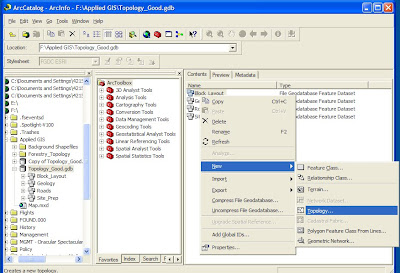
Once a geodatabase is created, and contains the desried feature datasets within it, topolgy rules can be set. In order to do this:
- Open ArcCaralog and select the feature dataset you wish the topology rules to be applied to.
- Right click and go to New/Topology.
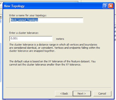
- Enter a title and the desired cluster tolerance (discussed in last weeks blog entry)
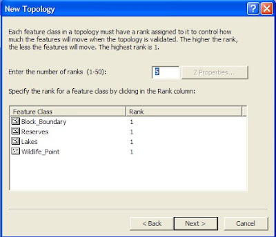
- Select which feature classes will participate in the topology
- Ranks can now be assigned to each of the feature classes (Discussed in last weeks clutser tolerance entry)
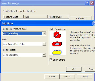
- Rules can now be added by selecting "add rule" and defining the rules by selecteing wihcih feature classes will eb involved and which rule will apply.
- Once satisfied lick next and finish, the topology will then be created as a feature class within the dataset and can be validated.
Monday, November 2, 2009
Cluster Tolerance
One of the primary drivers behind topology creation is cluster tolerance. It is the distance range in which all vertices and boundaries within a feature dataset are considered identical. For example, if two lines end beside each other within a predetermined distance (cluster tolerance) they will be considered the same when validating topology. This will snap them together and form one line.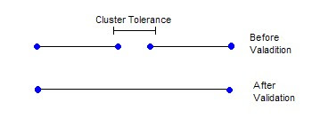
Ranks can be set to determine which lines will be snapped together. Higher ranked features will snap to each other before they snap to lower ranked features. This can be useful for snapping different classes of roads together or ensureing only data with the same accuracy levels snaps together. In the following diagram assume all lines end within the cluster tolerance.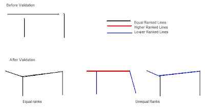 As a rule of thumb, cluster tolerance should be set 10 times smaller than the highest accuracy of your data. Therefor if your data was accurate to 10m your cluster tolerance would be .1m.
Note: The date on this post should be October 28th, but pressing save instead of publish delayed the publishing of this post until now.

Ranks can be set to determine which lines will be snapped together. Higher ranked features will snap to each other before they snap to lower ranked features. This can be useful for snapping different classes of roads together or ensureing only data with the same accuracy levels snaps together. In the following diagram assume all lines end within the cluster tolerance.
 As a rule of thumb, cluster tolerance should be set 10 times smaller than the highest accuracy of your data. Therefor if your data was accurate to 10m your cluster tolerance would be .1m.
Note: The date on this post should be October 28th, but pressing save instead of publish delayed the publishing of this post until now.
Subscribe to:
Comments (Atom)

