Tuesday, December 1, 2009

Project Conclusion

As a conclusion to my project I have come up with a list of strengths and weaknesses for the application of topology to solve a forestry database accuracy problem.

Strengths of Topology
  • Uses file geodatabases which are easier to edit and take up less space than other systems
  • Allows you to easily set out constants of how features share their geometry
  • Allows you to easily enforce the integrity of the data
  • Allows quicker identification and editing of errors
Weaknesses of Topology
  • Expensive and tiem consuming to convert and entire database from shapefiles into file geodatabase
  • Lost time creating topology rules and finding rule which fit your exact situation
  • Not all rule are perfect for forestry applications and may need exceptions and manual editing

Sunday, November 22, 2009

The uses of topology

As a conclusion to all previous topology explanation posts and the how to create a topology demonstration the following is a list of the relevant uses of topology.

  1. Managing and constraining how features share their geometry. Ie. Making sure adjacent FRI polygons share edges.
  2. Defining and enforcing rules which maintain the integrity of data. Ie. Not having gaps between features or ensuring all roads are connected.
  3. Support of navigation and increased efficiency when querying data by topological relation. Ie. Finding features that share endpoints or edges.
  4. Efficient editing of features to enforce the topology rules enforced on the data using powerful editing tools. Ie. Ability to edit a shared edge and update all features that share that common edge.
  5. Construct features from unstructured geometry Ie. The amalgamation of a mess of unconnected lines into continuous lines using cluster tolerance.
Source. An interpretation of the "Why Topology" section found within ESRI's GIS Topology White Paper. http://www.esri.com/library/whitepapers/pdfs/gis_topology.pdf

Wednesday, November 11, 2009

Topology Validation

Once a topology has been created in ArcCataloge, it needs to be validated in order to recognise where errors occur. This is an option given to you immidately after creating a topology in ARcCatalog. It can also be done at a later date in ArcMap. Using this option will let you select wether you would like to validate the entire topology or jsut a section of it, to save time when editing smaller areas.


The three buttons with checkmarks on them, shown above on the topolgy toolbar, are topology validation tools. Going from left to right is the validate topology in specified area, validate topology in current extent and validate entire topology tools.


Validate topology in specified area

Select this tool and drag a box around the area you would like to validate.


Validate topology in current extent

Select this tool to validate eveyrhting shown in the current extent of the screen


Validate entire topology

Select this tool to validate the entire topology


Once topology has been validated, errors will be highlighted within the topology layer in ArcMap in red. Below is a before and after validation picture of a topology error that occured because two features of the same type overlapped eachother.


Wednesday, November 4, 2009

Entering Topology Rules

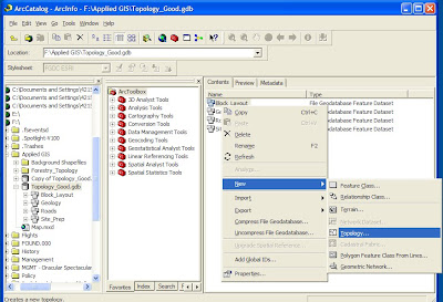
Once a geodatabase is created, and contains the desried feature datasets within it, topolgy rules can be set. In order to do this:
  1. Open ArcCaralog and select the feature dataset you wish the topology rules to be applied to.

  2. Right click and go to New/Topology.


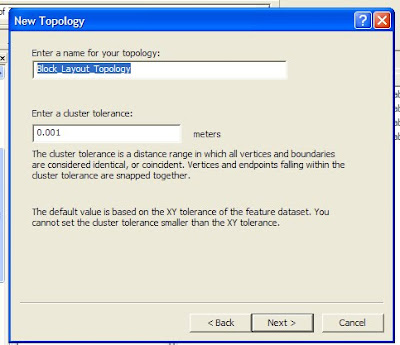
  3. Enter a title and the desired cluster tolerance (discussed in last weeks blog entry)


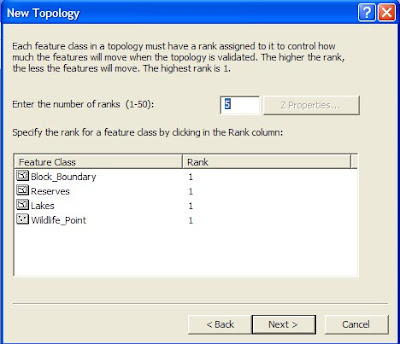
  4. Select which feature classes will participate in the topology


  5. Ranks can now be assigned to each of the feature classes (Discussed in last weeks clutser tolerance entry)


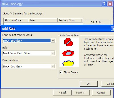
  6. Rules can now be added by selecting "add rule" and defining the rules by selecteing wihcih feature classes will eb involved and which rule will apply.


  7. Once satisfied lick next and finish, the topology will then be created as a feature class within the dataset and can be validated.

Monday, November 2, 2009

Cluster Tolerance

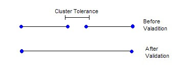
One of the primary drivers behind topology creation is cluster tolerance. It is the distance range in which all vertices and boundaries within a feature dataset are considered identical. For example, if two lines end beside each other within a predetermined distance (cluster tolerance) they will be considered the same when validating topology. This will snap them together and form one line.
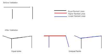
Ranks can be set to determine which lines will be snapped together. Higher ranked features will snap to each other before they snap to lower ranked features. This can be useful for snapping different classes of roads together or ensureing only data with the same accuracy levels snaps together. In the following diagram assume all lines end within the cluster tolerance.As a rule of thumb, cluster tolerance should be set 10 times smaller than the highest accuracy of your data. Therefor if your data was accurate to 10m your cluster tolerance would be .1m.


Note: The date on this post should be October 28th, but pressing save instead of publish delayed the publishing of this post until now.

Wednesday, October 21, 2009

Topology Rules Explained

To clarify a previous post where the project's topology rules are stated, the following is an explanation of each given topology rule in detail.

Must contain point

A polygon in one feature class must contain a point from another feature class. The point must be within the polygon, not on the boundary. Used to ensure each lease polygon contains a resource extraction point.


Endpoint must be covered by

The endpoint of a line must be covered by a point from another feature class. Used to ensure each pipeline ends in a resource extraction point.

Must be properly inside

Requires that all the points of one feature class fall within the polygons of another feature class. Used to ensure that each resource extraction point falls within a polygon.

Must not overlap

A line feature cannot overlap another line of the same feature class. Used to ensure that creeks and roads never share segments but can still intersect.

Must not self overlap

Ensures that a line feature cannot overlap itself. This will be used with roads that end in a loop, ensuring the loop doesn't overlap the remainder of the road.

Must be covered by

Points from one feature class must be covered by a line in another feature class. This will be used to ensure that all crossings are located along a segment of a road.

Must not overlap with

The interior of one polygon cannot overlap with that of another polygon in a different feature class. This will be used to ensure that boundary polygons do not overlap lakes.

Must not overlap

The interior of one polygon cannot intersect another polygon of the same feature class. This will be sued to ensure that reserves do not overlap.

Must not have gaps

This rule ensures that there no voids or gaps within a polygon or beside adjacent polygons of the same feature class. This will be used to ensure that site prep polygons all fit tightly togther within a harvest black boundary without any gaps.

Must cover each other

Requires that the polygons of one feature class must share all of their area with the polygons of another feature class. This will be used to ensure that the site prep polygons fit exactly on top of the harvested blocks polygon.

Wednesday, October 14, 2009

Topology Rules for Project Design

In order to showcase the many uses of topology, a wide variety of topological rules will have to be applied to this database. The following is an outline of of the feature datasets that will be used and the rules that will be applied to them. Feature classes are in regular print while topological rules are in bold.

Resource Extraction Dataset

  • Lease sites must contain Resource Extraction point
  • Pipelines endpoint must be covered by Resource Extraction point
  • Resource extraction point must be properly inside of Lease site
Block Creeks Dataset

  • Creeks must not overlap
Block Road Dataset

  • Roads must not overlap
  • Roads must not self overlap
  • Crossings must be covered by Roads
Block Boundary Dataset

  • Block boundary must not overlap with Lakes and rivers
  • Reserves must contain point Wildlife points
  • Reserves must not overlap
Site Preparation Dataset

  • Type of site prep. must not have gaps
  • Harvested blocks must cover Type of site prep.
For clarification of further blogs the heiarchy of data will be explained below with 1 being the largest file and highest level.

  1. File Geodatabase
  2. Feature Dataset
  3. Feature Class
You must be working within a geodatabase in order to apply topology rules to feature classes within a feature dataset.

Tuesday, October 6, 2009

Project Design

Topology is of a special importance to forestry data entry due to the large amount of GPS data collected. This project will be based around simulated GPS data collection being overlayed onto a base dataset, which will be topology and geographically correct.

Project Title: Using topology to simulate problems that can arise during data entry in forestry situations when several uncorrected feature datasets are overlayed on a topologically correct dataset.

the base dataset, which will be taken from CANFOR Grande Prairie divisions FMA, will include the following topologically correct layers:

  1. Routed roads
  2. Lakes and rivers
  3. AVI vegetation inventory
  4. Harvested blocks
  5. Pinelines
  6. Lease sites
  7. Net loss
The simulated forestry operations which will have collected GPS data that will be overlayed onto the base data will each be in their own data set. This will allow topology rules to be set which will correct each data set while allowing interaction between data sets ie. Resource extraction points must fall within lease sites.

GPS block layout data

  1. Block boundary (poly)
  2. Block roads (line)
  3. Crossings (point)
  4. Block creeks (line)
  5. Wildlife points (point)
  6. Resource extraction points (point)
  7. Reserves (poly)
Site preparation

  1. Type of site prep. within block (poly)
  2. Site prep. lines (line)
  3. Fuel Caches (point)
  4. Points of interest (point)
Beetle probing

  1. Plot center (point)
  2. Transect lines (line)
  3. Plot outline (poly)
  4. Beetle locations (point)

Wednesday, September 30, 2009

Topology Explained

Topology as explained by ESRI can refer to a:
  • Theory or mathematical model of features in space
  • Mechanism that allows features in the same or different feature classes to share geometry
  • Set of editing tools that works with features in an integrated fashion
  • Physical data model for feature data
  • Set of validation rules for geographic features
  • Mechanism for navigating between features using topological relationships

Topology is primarily used in order to ensure that data has been entered cleanly and accurately. A variety of editing tools ca be used to achieve this such as snapping of features to each other, validation tools and the setting of topological rules. Topology essentially allows the user to edit and view features in a way that supports the relationships between different feature classes.

The characteristics of topology are defined within ArcCatalogue and follow the following rules:
  • Topology can contain multiple point, line and polygon feature classes oritented onto a 2D plane
  • All features must have the same spatial reference within the data set
  • Multiple topologies can exist within the data set
  • Features can only be associated with one topology
  • Features cannot be associated with both a topology and a geometric network
More to be added as project continues.

Sources:
ArcGIS: Working with Geodatabase Topology
http://www.esri.com/library/whitepapers/pdfs/geodatabase-topology.pdf
Understanding Topology and Shapefiles
http://www.esri.com/news/arcuser/0401/topo.html